
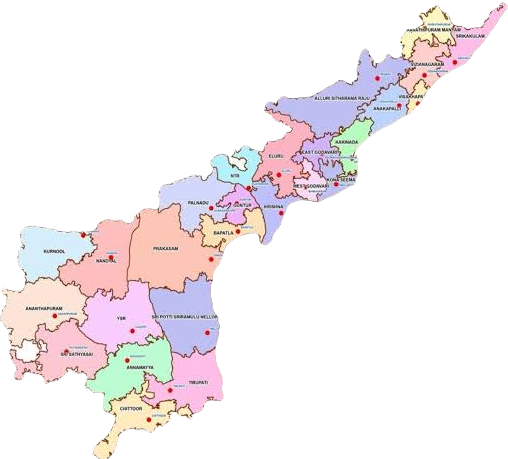
Andhra Pradesh is one of the five states in the Southern part of India located at the coordinates 16.51°N 80.52°E. It is 7th largest state with an area of 162,970 km2 and the tenth-most populous state with 49,577,103 inhabitants based on 2011 census data. It shares a border with Odisha towards North East , Chattisgarh in North, Telangana towards North West, Karnataka to the west and Tamil Nadu in the south along with Yanam(Puducherry UT) on the east coast. Andhra Pradesh has the second longest coastline in India with the approximate length of 974 km.
Here are Key Census Statistics of Andhra Pradesh
- Andhra Pradesh Total Area : 162,970 km2
- Total Population (2011 Census) : 49,577,103 – [5.4 Crore population estimated as of 2024]
- Population Density of Andhra Pradesh: 304/km2
- Total number of districts: 26 districts
- Border States: Odisha, Chattisgarh, Telangana, Karnataka, Tamil Nadu, Yanam(Pondicherry UT)
- District with Highest population density: Visakhapatnam (of 26 districts) and lowest population density in Alluri Sitaramaraju district
- Urban population of Andhra Pradesh: 14,610,372
- Rural population of Andhra Pradesh: 34,966,730
- Capital city of Andhra Pradesh: Amaravati
- Largest city of Andhra Pradesh: Visakhapatnam
- Area wise largest district of Andhra Pradesh: Prakasam (14,322 sq km)
- Smallest District of Andhra Pradesh: Visakhapatnam (1,048 sq km area)
- Most populated district of Andhra Pradesh: SPSR Nellore (24,69,712) This content is prepared by StudyBizz.com
- Least Populated district of Andhra Pradesh: Parvathipuram Manyam (9,25,340)
- Sex Ratio of Andhra Pradesh: 997 males per 1000 females [National average 926]
- CSR : 939 male children per 1000 female children
- Literacy Rate of Andhra Pradesh: 67.02% (less than India’s Literacy Rate: 74.04%)
- Male Literacy Rate of Andhra Pradesh: 74.88%
- Female Literacy Rate of Andhra Pradesh: 59.15%
- District with Highest Literacy Rate: West Godavari (erstwhile) and District with lowest literacy rate: Vizianagaram (erstwhile)
- SC Population of Andhra Pradesh: 17.08%
- ST Population of Andhra Pradesh: 5.53%
- District with Highest SC Population in Andhra Pradesh: Tirupati
- District with Highest ST Population in Andhra Pradesh: Alluri Sitaramaraju district.
Detailed population of each district and its map, Revenue divisions, list of Mandald can be accessed from here
Join us on WhatsApp channel for all latest Job updates and Educational content


Leave a Reply